One Week Itineraries

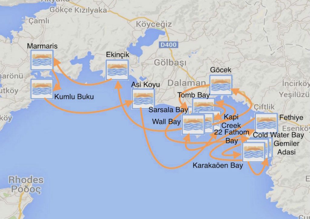
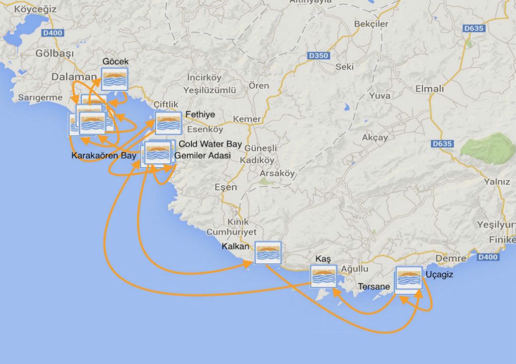
Option 1 – Skopea Limani, Fethiye – 70 Nautical Miles|
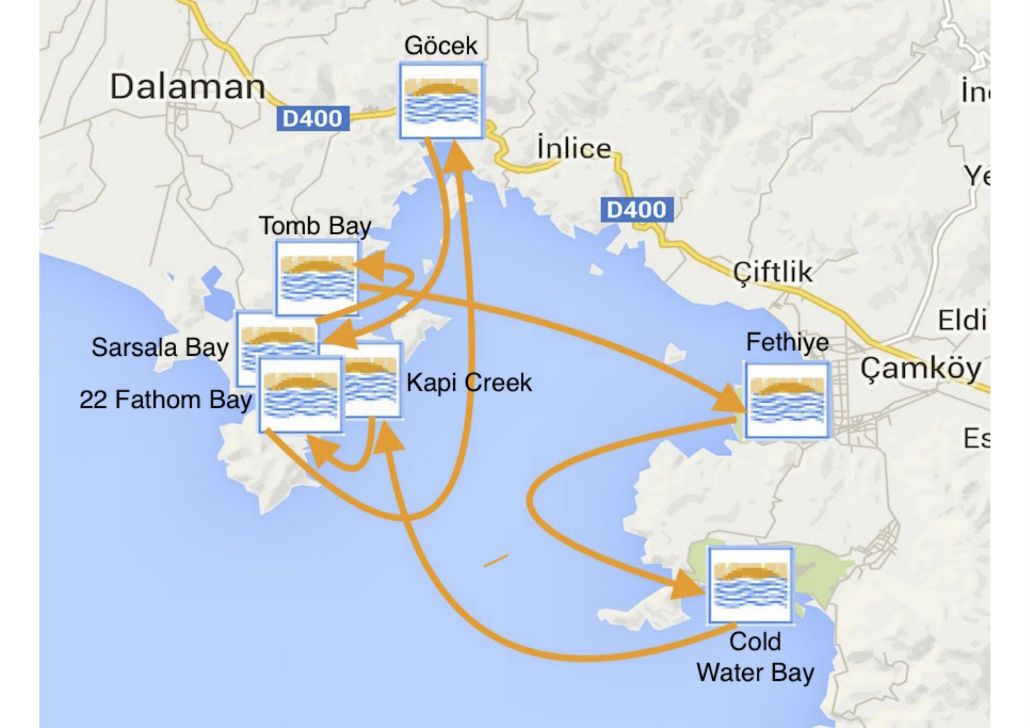
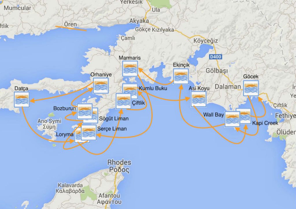
Option 2 – Skopea Limani, Marmar – 120 Nautical Miles
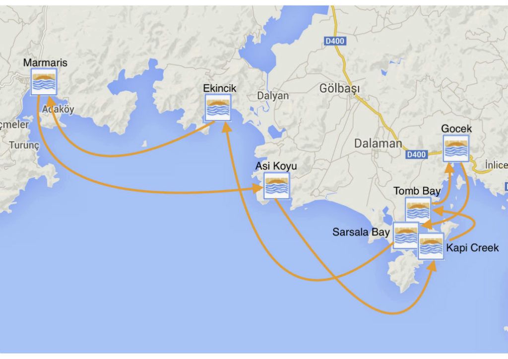
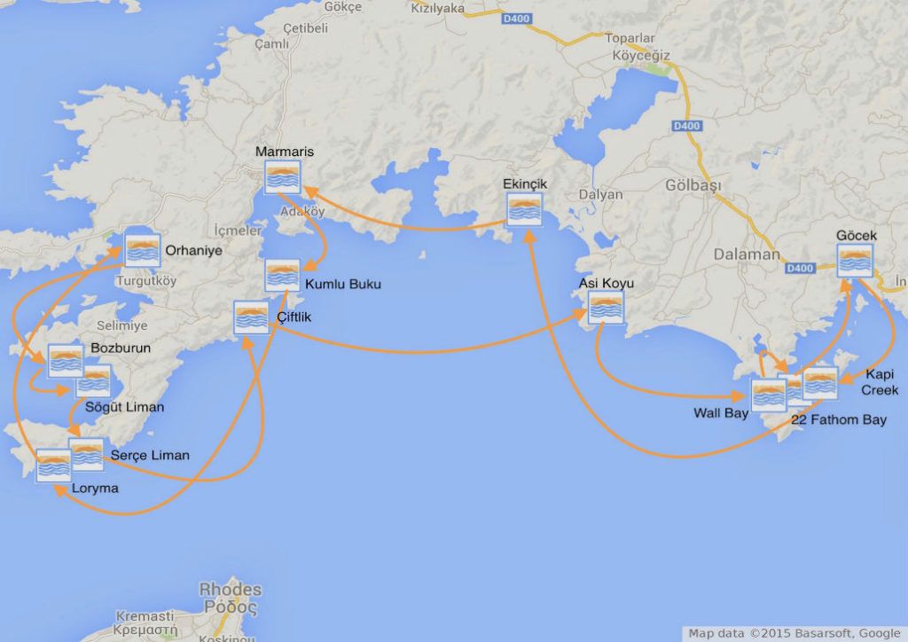
Option 3 – Marmaris and Beyond – 120 Nautical Miles

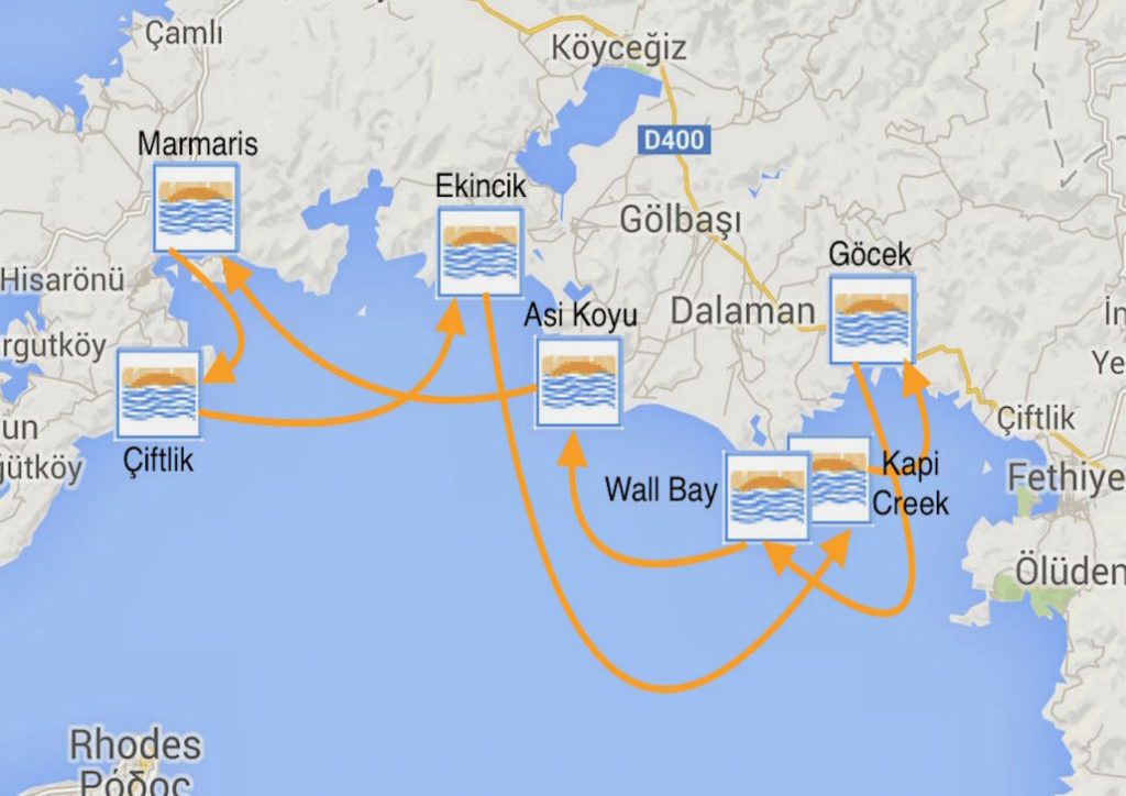
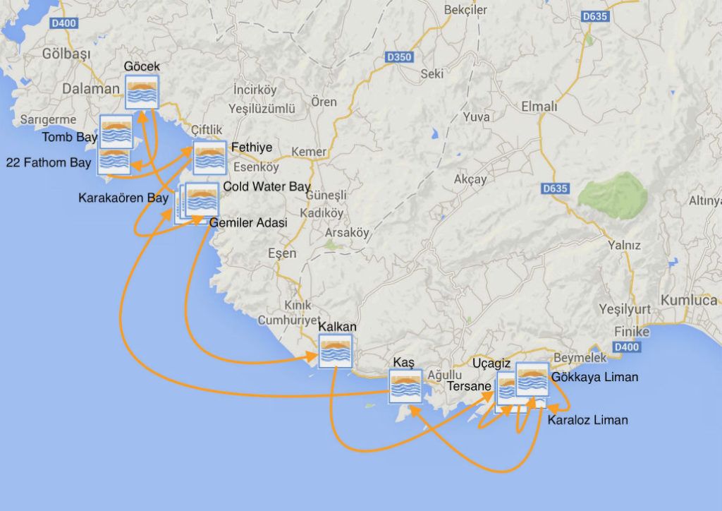
Option 4 – Fethiye, Kalkan and Kaş – 135 Nautical Miles

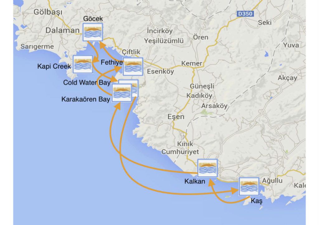
Option 5 – Kaş and The Kevova Roads – 175 Nautical Miles

Back to entire sailing area chart …

Two Week Itineraries

Option 1 – Skopea Limani, Fethiye, Marmaris – 180 Nautical Miles

Option 2 – Marmaris Peninsula, Datça – 240 Nautical Miles

Option 3 – The Marmaris Peninsula – 220 Nautical Miles

Option 4 – Skopea Limani, Kalkan and Kaş – 210 Nautical Miles

Option 5 – Kalkan, Kaş, The Kekova Roads – 195 Nautical Miles

To go back to full sailing area chart, click here.

Loryma (aka Bozukkale) 36°34.1′N, 28°01.1′E

Overlooking the coves is a large, very well preserved Hellenistic castle. Here the Athenian fleet was sheltered during the Peloponnesian War before the battle of Knidos.  It has other significant history of warring fleets, one being in the service of Alexander the Great.  The castle was built on the east hill of the entreance of the Loryma Bay for protection.

There are several restaurants competing for the yacht business by offering laid moorings.  You can either accept one of their moorings or anchor off-shore at 8-10 metres.  There are small pontoons in front of the restaurants. Boats up to 60′ can be accommodated.

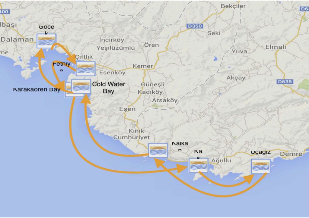
Alternatively, anchoring in various positions in the bay is also possible.  The bottom is weed and you should look for a patch of sand to drop anchor.  Take care since holding is not always reliable.  Just inside the entrance, is a cove under the citadel in 8-10 meters to anchor and take a line ashore.  There are two coves on the western side in 5-8 meters.  Also, there are two coves near the head of the bay in 5-10 meters where you can taker a line ashore.

Facilities

  • Several restaurants
  • Mooring available on restaurant pontoons
  • Anchoring in various coves
  • No harbour

Back to One Week Itineraries

Back to Two Week Itineraries

Karaloz Liman/ The Kekova Roads 36°10.9′N, 29°53.6′E

The cove is totally secluded and affords a wonderful anchorage for several boats.

The water is crystal-clear and the bottom is mud and weed with good holding.

There can be, however, strong gusts so it is best to take a line ashore.

Facilities

  • No restaurnats
  • Anchorage only

Back to One Week Itineraries

Back to Two Week Itineraries

Gökkaya Liman/ The Kekova Roads  36°12.4′N, 29°54.0′E

Several idyllic and peaceful sheltered anchorages, protected by small islands make up this cove at the eastern end of Kekova Roads.

Gökkaya Liman can be entered from S, SE or E.  The approaches all have good depths but extreme care should be taken to avoid reefs and underwater rocks with very little coverage.  The approach from the E passes under power lines with a clearance of at least 25 metres.

Anchoring is possible anywhere with suitable depths. The holding is good on mud and sand. Popular anchorages are in the inlet running west from the centre of the cove in 3–5 metres depth where you can take a line ashore and in the NW corner with 3–7 metres. One disadvantage of this anchorage is that day tripper boats occasionally moor up overnight amidst revving of engines and shouting.  It is thus absolutely essential to use a good anchor light here if staying overnight.

There is a  steady flow of fresh water from an inland spring that keeps the cove cool.  There is also a sea cave at the SE end of the islet reachable by dinghy. On the west side, there are the ruins of a Byzantine church.  Also, part of the Lycian Way runs along the west side and can be explored on foot.  Finally, it is possible to leave the boat and visit Demre and Myra, just 2nm away, by dingy.

Facilities

  • No restaurant; a rustic bar provides basic refreshments
  • No jetties
  • Anchorage only
  • See important note on entering the Kekova Roads area on The Kekova Roads page

Back to One Week Itineraries

Back to Two Week Itineraries

Kale Köy/ The Kekova Roads  36°11.3′29°51.7′E

Kale Köy was the ancient Lycian town of Simena and is very picturesque, dominated by a Crusader castle, necropolis and submerged tombs protruding from the water.  It needs to be approached with care because of the numerous reefs.

The bottom is mud and weed over rock and does not provide secure holding.  It is better to either anchor inside Uçagiz Liman and visit by dinghy or to berth alongside at one of the three 50-metre long pontoons provided by restaurants.  Each can accommodate 2 to 3 yachts on either side of their pontoon. Depths range from 4.5 to 12–14 metres..  There are shallows about 20 metres west of the pontoons, which need to be avoided when berthing.

The medieval castle at the top of the village and the ancient theatre inside are well worth the climb.  The necropolis a few hundred yards to the east of the castle is also worth a visit. There are a number of intact Lycian tombs in an impressive setting overlooking Kekova Roads.

If berthed at the pontoons, it is an 800 metre dinghy trip over to Kekova Island to visit the stunning ruins of the ancient Lycian city on its north shore.

Once the day tripper boats leave by 18:00, Kale Köy reverts to a charming Turkish fishing village.

Facilities

  • Several restaurants
  • Pontoons for approximately 15-20 yachts
  • Anchoring is not recommended
  • Water and electricity are available
  • WIFI is available in restaurants
  • See important navigation note on The Kekova Roads page

Back to One Week Itineraries

Back to Two Week Itineraries

Tersane/The Kekova Roads  36°10.36′N, 29°50.77′E

Tersane is a tiny, well-sheltered cove on the NW side of Kekova Island.  If there is room, since it is generally packed with tripper boats during the season, you can anchor in 4-5 metres and take a line ashore to either side. The bottom is sand and rock and provides good holding.
DCIM100MEDIADJI_0024.JPG

There are a couple of ropes tied through the rocks on either side of the inlet which can be used to take a stern line.  However, tripper boats come and go all day from morning until late night.  Since the daytime wind tends to blow down the inlet, they lay their anchors to the wind while their clients go for a splash.  This means an anchor chain laid across the inlet is likely to eventually be snagged by one of them.  Given this, arriving late and leaving early, at least during the season, tends to be a good plan.

At its head, the cove is dominated by a collapsed arch of a Byzantine church.  To the east of the cove, one can see many submerged ruins (Hellenistic, Roman, Byzantine). Snorkeling here, in the crystal-clear water, is definitely worth your while, despite the endless procession of day-trip boats with glass bottoms and loudspeakers.

If you cannot find room to anchor in Tersane, a possible visit from Kale Köy or Uçagiz by dinghy is worth while.

Facilities

  • Anchorage only
  • No harbour
  • No restaurant

Back to One Week Itineraries

Back to Two Week Itineraries

Datça 36°43.10′N, 27°41.06′E

Datça used to be a pleasant harbour in a sleepy provincial town. In the last few years, however, it has grown into a booming resort with high-rise buildings, bars and nightclubs.  The harbour at night can be noisy but it is still a convenient and interesting port.
The harbour has been upgraded and the area designated for yachts has been extended.  To the west, it has an area of decking and new stainless steel mooring rings along the quay.  It is now operated as a marina and can accommodate 30–40 yachts. However, it is a very popular so it is wise to arrive early during high season.  If the harbour is full, there are good anchorages both south and north of the harbour, depending on wind direction.

Yachts anchor and moor to the quay as directed by harbour staff.  Anchor in 5–6 metres and go back to the quay.  The holding is good in mud and sand. Water and electricity are available on the quay and are included in the mooring fee.

It is also possible to anchor off in either the South or North Bay, where the holding is good in sand.  The South Bay normally offers better protection in the prevailing winds and is just off the main town beach.  The water is clear enough to swim off your boat.

Facilities

  • Abundance of restaurants, bars, cafes and nightclubs
  • Variety of provisioning options
  • Harbour mooring for 30-40 yachts
  • Anchoring possibilities in north and south bays
  • Water, electricity available on the quay

Back to One Week Itineraries

Back to Two Week Itineraries

Orhaniye (aka Keçi Bükü) 36°46.7′N, 28°06.98′E

The bay stretches about 1.3 nautical miles.  After the entrance, on the left is the Marti Marina.  The marina has all the supply options and facilities of a modern marina.

While navigating further in, be mindful of a large sandbank in the southeast of the bay known as Kizkumu, or Maiden’s Sand.  It is a long, narrow sand pit, lying just at or slightly under the water surface.  While presenting  a bit of sailing hazard, it also provides a much-loved “photo op” for many.  When walked on, it looks as if you are walking on water. It is so enjoyed that, all you might need in spotting it are the people walking on it. Some believe that it is one aspect of the bay not to miss.

In the crest of the bay are several restaurants and bars with jetties, mooring lines and electricity/water.  Alternatively, there a lots of little inlets to anchor in, some with restaurants and a pontoon, many with nothing at all.

Orhaniye is a gem of a village and deservedly popular with visitors, of which you will see many.

Facilities

  • Several restaurants, bars and cafes
  • Marina facilities at Marti Marina (i.e. laundry, supermarket, swimming pool, showers, fuel station and restaurant)
  • Mooring at numerous jetties/pontoons around the bay

Back to One Week Itineraries

Back to Two Week Itineraries

Bozburun  36°41.46′N, 28°02.56′E

Bozburun is an attractive village that hugs a small, lovely harbour.  It lies on the Hisarönũ Peninsula at the head of a bay, opposite the Greek island of Simi.  The town is sheltered by several small islands and its setting is quite stunning.

There is an attendant in the harbor who will direct you in, usually side-to. There is water and electricity (included with the harbor dues) and fuel can be delivered.

Bozburin is charming and somewhat eccentric, being something of a magnet for entertainment and media types looking for a quieter life by the sea in Turkey.  There are many places for food and a cold drink, as one famous visitor, Bill Gates via his megayacht, could attest.

Lined along the walk that stretches from the harbor are a series of hotels with beach bathing platforms and small cafes.  A choice of any of them will provide a refreshing swim, food, refreshments and some pleasant “chill time.”

For mooring, go stern- or bows-to on the town quay where convenient.  Alternatively, anchoring is possible eastwards of the harbour where you can take a line ashore.  There are a few shallow patches to watch but, overall, there are sufficient depths.

Facilities

  • Many restaurants, cafes and bars
  • Small town but with sufficient provisioning
  • Harbour with electricity, water and fuel
  • Beach and numerous swimming platforms from the rocky shoreline

Back to One Week Itineraries

Back to Two Week Itineraries